

Actualités sur les radiosondes, les ballons haute altitude, et la météorologie.
mercredi 30 mars 2016
launch between 12/04/16 and 20/04/16 from Westcott, Buckinghamshire
Hellooo!
As you probably know, Tim Peake is running the London Marathon in space. You might not know that Fuller’s brewery is providing a pint of London Pride for every runner at the end of the race. But how are they going to get one to Tim? We’ve teamed up with Fuller’s to try and get it as close to Tim as we can using a HAB. Unfortunately our balloon won’t carry a pint all the way to the ISS, but it’s the thought that counts :). We’ve called this flight ‘Princibeer’ (see link below). As well as the Habduino, 2 GoPros and a data logger, the payload will contain a whole pint of London Pride in an evacuated pouch (surrounded by several layers of waterproofing).
We are aiming to launch between 12/04/16 and 20/04/16 from Westcott, Buckinghamshire.
Standard 5/30000/5 flight with an 800g Hwoyee and payload mass of about 1700g. This batch of Hwoyees seems to be extra stretchy. Our previous 3 flights have burst 3-4km higher than anticipated and landed in less than ideal locations (*cough* Lakenheath *cough*). So we’ll test out a few scenarios on the predictor nearer the time and pick a good day.
Habduino will be transmitting on 434.5MHz. Any help with tracking would be much appreciated!
434.5MHz USB RTTY 50 baud 480Hz shift ASCII-7 no parity 2 stop bits
More info nearer the time!
https://www.dropbox.com/s/b326ci7tz2wh92k/Principia_mission_logo.jpg?dl=0
Many thanks,
Sammy
Source directe : UKHAS
From : Alan F6AGV
samedi 26 mars 2016


AMATEUR RADIO HIGH ALTITUDE BALLOONING LAUNCH ANNOUNCEMENTS au 26 mars 2016
LAUNCH ANNOUNCEMENTS:
- 2016-04-02 @ 09:00 MST
- Arizona Near Space Research
To Launch: ANSR-97
Website:http://www.ansr.org, http://groups.yahoo.com/group/Ballooning/
APRS.FI: KA7NSR-6
Telemetry: APRS: 144.340Mhz,
Site:
Coords: 33.0729, -111.975 Grid: DM43AB
Contact: Bill McLean bmclean@netzero.net
QRZ: KA7NSR
Ascend Flight 22 - 2016-04-09 @ 09:00 CDT
- Middle Tennessee Robotic Arts Society
To Launch: MTRAS2-Balloon
Website:http://www.mtras.com
APRS.FI: KI4NHK
Telemetry: APRS: 144.390Mhz,
Site: Oak Ave CoC, Dickson, TN, USA
Coords: 36.0838, -87.3871 Grid: EM66HC
Contact: Carlton Corbitt ki4nhk@ki4nhk.com
QRZ: KI4NHK
This is a 3, 1500g balloon cluster
2 payloads, FoxHunt on 146.565MHz Morse Code on FM, Cameras on both payload s, and parachute return experiment, 433.97388MHz backup beacon, accelerameter position experiment - 2016-04-09 @ 11:00 EDT
- Ivy Near Space Program for Computing Technologies
To Launch: INSPCT-4
Website: None given
APRS.FI: KC9VVJ-11
Telemetry: APRS: 144.390Mhz, 1258 MHZ (ATV)
Site: Goshen Airport, Goshen Indiana
Coords: 41.5263, -85.7942 Grid: EN71CM
Contact: Dave Bohlmann dbohlmann@ivytech.edu
QRZ: KC9VVJ
Chase team will use 145.75 MHz FM Voice - 2016-04-16 @ 10:00 CDT
- Nebraska Stratospheric Amateur Radio
To Launch: NSTAR 16-A
Website:http://www.nstar.org/
APRS.FI: N9XTN-11, N9XTN-12
Telemetry: APRS: 144.340Mhz, 144.390MHz
Site: UNL Hardin Hall, Lincoln, NE, USA
Coords: 40.8292, -96.6718 Grid: EN10PT
Contact: Mark Conner mconner1@gmail.com
QRZ: N9XTN
Launch time tentativeEvent at Central Plains Severe Weather Symposium - 2016-05-14 @ 09:30 CDT
- Central Nebraska Near Space Program
To Launch: CNNSP-11
Website:http://www.cnnsp.org/
APRS.FI: KC0MWM-11, KC0MWM-12
Telemetry: APRS: 144.340Mhz,APRS: 144.390 MHz, CW beacon 146.565 MHz
Site: Aurora, NE
Coords: 40.8585, -97.9958 Grid: EN10AU
Contact: Roger Hammond kc0mwm@gmail.com
QRZ: KC0MWM
Edgerton Explorit Center
Visit us at http://arhab.org for more information.
Use this form to submit your launches: http://www.arhab.org/hab_launch_form.php
Good Luck!
73s -- Keith, WA0TJT
Source directe : ARHAB USA
From : f6agv (@) free.fr
prévisions des radiosondes
The forecast radiosondes are suspended.
Les prévisions des radiosondes sont suspendues.
73 Alain F6AGV
from : f6agv (@) free.fr
Les prévisions des radiosondes sont suspendues.
73 Alain F6AGV
from : f6agv (@) free.fr
ANNONCE BALLON F le 26 mars 2016
Hello
I am planning my first launch of a HAB payload run by a Raspberry Pi. We
are launching from 1.5 hours south east of Paris, France.
Since this is my first launch, I am hoping that I can get other listeners
to help out. Thanks in advance for listeners.
Date: 26/03/2016
Frequency 434.388 MHz
Call sign - FRINUS
Launch time - between 8-10 am CET
Thanks
Source directe : UKHAS
From : f6agv (@) free.fr
lundi 21 mars 2016


dimanche 20 mars 2016
PREVISIONS du 21 mars 2016 (H, M, T et U)
Les prévisions sont données à H-18 exceptionnellement et seulement les 0Z.
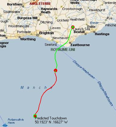


BALLON UK XABEN-93 le samedi 19 mars 2016 réussite !

Pour ceux qui ne connaissent pas bien comment fonctionne le système "tracker.habhub.org", voici quelques explications simples. Sur cette image, que tout le monde peut regarder en ouvrant le site, nous observons :
---les charges utiles PrjHeT (en violet) et X0 (en bleu et jaune).
---les traits verts qui convergent vers la charge X0 sont les traces des stations d'écoute, qui reçoivent les trames émises par ces charges utiles. Les stations sont des écouteurs amateurs non licenciés ou ayant un indicatif d'écouteur, ou des radioamateurs licenciés.
Le système tracker.habhub.org permet à Monsieur Tout le monde ayant un poste 434 et une antenne de participer en contribuant à établir la trajectoire et à archiver les données dans le serveur centralisé, moyennant le logiciel DL-FLDIGI et une liaison internet.
---les trajectoires des charges utiles sont tracées grâce aux données reçues par les écouteurs. Le système serveur prolonge les trajectoires avec une prévision de trajectoire, le point de chute (impact) étant signalé par une cible. Il y a un ajustement permanent de la
prévision au fur et à mesure du vol.
---les véhicules suiveurs (ou chases cars) sont visibles sur la même carte que les charges utiles. Une réception des trames de données transmises par les ballons est faite dans chaque véhicule et renvoyée sur le serveur tracker.habhub.org par une liaison internet.
A bord du véhicule, il est possible d'observer la position du ballon et la position du véhicule.
Avec la vue "map" (carte) ou la vue satellite.

Sur la colonne de gauche, vous pouvez voir:
---l'indicatif de la charge utile (X0 pour XABEN-93).
---le profil du vol, ici montée et descente en cours (parachute déployé)
---la vitesse de descente verticale (en négatif)
---la vitesse du vent horizontale.
---l'altitude en temps réel et l'altitude maximale (éclatement)
---la date et l'heure (locale)
---les coordonnées GPS LAT et LON (en degrés décimaux)
---la tension batterie et d'autres paramètres.
---les indicatifs des stations d'écoute (pseudo ou SWL ou radioamateur)

Le véhicule de poursuite traverse une petite ville ! Pas d'arrêt au "pub" !
Certains véhicules sont équipés d'une caméra et les images en direct sont alors transmises via internet sur le site BATC.TV.

Les véhicules se suivent mais les points de chute sont séparés : XABEN-93 et PrjHET.
L'altitude est faible mais les points de chute peuvent encore changer de position !
Il faut tenir compte des vents au sol, qui ne sont pas connus du système tracker.habhub.org.

du sol peuvent réserver quelques surprises et faire dévier les trajectoires.

La charge utile PrjHeT est à l'altitude de 198 m et il n'y a plus d'autres points.
La charge utile Xaben-93 est divisée en deux ( bleu et jaune) Xaben0 et X0.
Le véhicule de G8KHW Steve est bien positionné pour observer les chutes dans le champ.
Une station capte encore le signal de Xaben0.

Cette dernière image nous montre les cercles verts de portées des émissions respectives et figure la position de la station d'écoute la plus proche du lieu de chute : hyde00001.
Épilogue :
Hi Folks
Thanks to everyone that listened for XABEN-93 today - it was easily recovered in field this afternoon and landed about 500m from PrjHeT. Following the successful recovery of both payloads the two teams went down a local pub for a well earned jar.
As far as X0 goes I notice that no LoRa packets were received by other stations - perhaps this was a lack of LoRa receivers - or was it due to decoding problems?
Steve
traduction rapide :
Salut les gens
Merci à tous ceux qui ont écouté XABEN-93 aujourd'hui (ndlr: le samedi 19 mars)- il a été facilement récupéré dans le champ cette après-midi et il a atterri à environ 500m de PrjHeT. Suite à la récupération réussie des deux charges utiles les deux équipes sont descendues dans un pub local pour un pot bien mérité.
En ce qui concerne X0 je remarque qu'aucun paquet de Lora n'a été reçus par d'autres stations - peut-être cela était du à un manque de récepteurs Lora - ou était-ce à cause de problèmes de décodage?
Steve
Commentaire :
Voilà un exemple de réussite de ces deux projets, qui utilisent le site "tracker.habhub.org"
dans sa forme la plus participative et non restrictive.
Une possibilité est offerte aux "spectateurs" sur la touche d'être impliqué et de vivre une partie de l'aventure au niveau du vol et des transmissions de données.
Les émissions des ballons font appel aux techniques numériques (ex : LoRa ) et les écouteurs peuvent s'équiper en réception et aussi expérimenter en émission.
L'usage de l' APRS sur un ballon en 144.800 ou en 144.390 devrait être utilisé dans les zones où il n'y a pas de station d'écoute ou de radioamateurs équipés en 434 MHz.
Par exemple : les traversées des océans ou des déserts.
Dans ce schéma, il n'y a qu'une personne concernée par la réception APRS.
Encore bravo aux deux équipes PrjHeT et XABEN-93 (le 93ème de la série).
Source directe : tracker.habhub.org & UKHAS
From : Alan F6AGV f6agv (@) free.fr
samedi 19 mars 2016


vendredi 18 mars 2016
AMATEUR RADIO HIGH ALTITUDE BALLOONING LAUNCH ANNOUNCEMENTS au 19 mars 2016
AMATEUR RADIO HIGH ALTITUDE BALLOONING
LAUNCH ANNOUNCEMENTS:
- 2016-04-02 @ 09:00 MST
- Arizona Near Space Research
To Launch: ANSR-97
Website:http://www.ansr.org, http://groups.yahoo.com/group/Ballooning/
APRS.FI: KA7NSR-6
Telemetry: APRS: 144.340Mhz,
Site:
Coords: 33.0729, -111.975 Grid: DM43AB
Contact: Bill McLean bmclean@netzero.net
QRZ: KA7NSR
Ascend Flight 22 - 2016-04-09 @ 09:00 CDT
- MTRAS
To Launch: MTRAS2-Balloon
Website: None given
APRS.FI: KI4NHK
Telemetry: APRS: 144.390Mhz,
Site: Oak Ave CoC, Dickson, TN, USA
Coords: 36.0838, -87.3871 Grid: EM66HC
Contact: Carlton Corbitt ki4nhk@ki4nhk.com
QRZ: KI4NHK
This is a 3, 1500g balloon cluster
2 payloads, FoxHunt on 146.565MHz Morse Code on FM, Cameras on both payloads, and parachute return experiment, 433.97388MHz backup beacon, accelerameter position experiment - 2016-04-09 @ 11:00 EDT
- Ivy Near Space Program for Computing Technologies
To Launch: INSPCT-4
Website: None given
APRS.FI: KC9VVJ-11
Telemetry: APRS: 144.390Mhz, 1258 MHZ (ATV)
Site: Goshen Airport, Goshen Indiana
Coords: 41.5263, -85.7942 Grid: EN71CM
Contact: Dave Bohlmann dbohlmann@ivytech.edu
QRZ: KC9VVJ
Chase team will use 145.75 MHz FM Voice - 2016-04-16 @ 10:00 CDT
- Nebraska Stratospheric Amateur Radio
To Launch: NSTAR 16-A
Website:http://www.nstar.org/
APRS.FI: N9XTN-11, N9XTN-12
Telemetry: APRS: 144.340Mhz, 144.390MHz
Site: UNL Hardin Hall, Lincoln, NE, USA
Coords: 40.8292, -96.6718 Grid: EN10PT
Contact: Mark Conner mconner1@gmail.com
QRZ: N9XTN
Launch time tentativeEvent at Central Plains Severe Weather Symposium - 2016-05-14 @ 09:30 CDT
- Central Nebraska Near Space Program
To Launch: CNNSP-11
Website:http://www.cnnsp.org/
APRS.FI: KC0MWM-11, KC0MWM-12
Telemetry: APRS: 144.340Mhz,APRS: 144.390 MHz, CW beacon 146.565 MHz
Site: Aurora, NE
Coords: 40.8585, -97.9958 Grid: EN10AU
Contact: Roger Hammond kc0mwm@gmail.com
QRZ: KC0MWM
Edgerton Explorit Center


Visit us at http://arhab.org for more information.
Use this form to submit your launches: http://www.arhab.org/hab_launch_form.php
Good Luck!
73s -- Keith, WA0TJT
Source directe : ARHAB USA
From : Alan F6AGV f6agv (@) free.fr
ANNONCES BALLONS DIVERSES au 19 mars 2016
Hi All,
Hopefully to give you all plenty of warning, we'll be assisting 23
schools to launch simultaneously on 12th May. All launches will be from
RAF Cosford and will be using PISKY with frequencies ranging from 434.04
to 434.79 (We'll be testing systems tomorrow but assuming they work
together these will be the frequencies). I'll of course keep everyone
updated as this progresses and I hope it doesn't put anyone out.
Best regards
Alex (BARC)
===========================================================
If you are launching several flights at once. Won't they all go the same way? Unless they have different rates of climb that is. Should look spectacular if you do launch several at once.
As Santa Pod is around 4 miles from me. I'm looking at the site for launches. You don't need to enter the site, as the peri road still runs around it. And a group of model aircraft flyers fly from a spot around 1/2 mile from the strip. This could also be the area where I'd launch from.
Anyone want to come over one Saturday or Sunday, next month to look at the location? If so let me know. Maybe a small balloon/pico launch could be made, as it would be easy to do. And you don't need C.A.A. clearance for them.
==========================================================
Hi
I'm a A level student who is planning on building a weather balloon as part of my Extended Project Qualification. I plan on sending a balloon up to take measurements of temperature, pressure and humidity using a arduino board with sensors. Me and my ICT teacher are going to figure out a way to track it using the arduino board. Being a student I have a very small budget and I plan on emailing companies to ask for funding. Do you know of any companies or organisations who would be willing to help or lend me equipment and advice?
Any advice, contacts or general information be would be highly appreciated.
=========================================================
Hi Folks,
I’m intending to launch a balloon this Friday(probably) or Saturday - depending on wind and weather. The flight will be a test of an RN2483 based LoRa tracker.
The tracker puts out LoRa and RTTY strings:
LoRa:
EXPLICIT_MODE;
ERROR_CODING_4_8;
BANDWIDTH_20K8;
SPREADING_11;
LowDataRateOptimize Enabled;
RTTY:
75baud
490Hz shift
7N2
Both:
434.405MHz
Callsign: X0
There will be a backup tracker on 434.300MHz (50baud, 600Hz shift, 7N2) callsign: XABEN0.
Listeners would be very much appreciated.
Launch time details closer to the launch.
Steve G8KHW
Hi Steve,
where did you buy the RN2484 modules from? I saw them at Mouser, but no stock available.
Best regards,
Uli
Yeah - likewise at Farnell etc. - pretty sold out across Europe as far as I can tell - lots of interest in the IoT world I think. I tried to get some more recently without any luck - but a very kind HABer had a couple that he let me have.
As standard they are bit restrictive (only Lora Bandwidth values 125, 250 & 500KHz are supported). They need re-programming to be useful IMO. The flight tomorrow will give some pointers to frequency stability etc. If that works out I’m planning on doing a PCB.
Here is a pic of whats flying tomorrow:
https://www.flickr.com/photos/16828840@N07/albums/72157663705117764
Steve
Looks cool! Apparently, you are using the embedded micro of the module to read the ublox via i2c and build the telegram? - Good luck for your flight!
Uli
As standard they are bit restrictive (only Lora Bandwidth values 125, 250 & 500KHz are supported). They need re-programming to be useful IMO.
Well, the modules intended purpose is LoRaWAN so you can understand why the bandwidth is high. Devices will be pretty much guaranteed to be within frequency capture range without requiring close tolerance crystals.
Anyway good luck, if it goes well I might even be tempted to do some Great Cow Basic routines for the device.
++++++++++++++++++++++++++++++++++++++++++++++++++++
Hi all,
This is to announce the launch of a high altitude balloon called AGENA 2. It will be launched from the south of the Netherlands.
Location: Heerlen, Netherlands.
Time: 26/03/2016 - 10:00Z / 11:00CET
Receiving info:
RTTY at 434.325 MHz, 150 Baud, 450 Hz shift, 8 ASCII, no parity, 1 stop bit.
Types of transmission:
Telemetry string every ~35 seconds, SSDV image (600 BAUD) every ~ 10 minutes.
Any changes to the plan will be posted here.
Happy HAB'ing :)
++++++++++++++++++++++++++++++++++++++++++++++++++++
Postponing todays launch. More details later.
18th mar
Steve
+++++++++++++++++++++++++++++++++++++++++++++++++++
Now expecting to launch tomorrow: 19th mar
Steve
++++++++++++++++++++++++++++++++++++++++++++++++++
This is basically a repeat of last month's 868MHz LoRa flight, with some tweaks to the tracker code.
There'll be LORA 868 and RTTY 434 to listen to. Images on LORA only.
The expected flight path doesn't it far from here so I'm expecting good coverage on my 868 and 434 till it gets fairly low.
More details next week.
Dave
==================================================
Source directe :UKHAS
From : f6agv (@) free.fr


jeudi 17 mars 2016


mercredi 16 mars 2016


mardi 15 mars 2016


lundi 14 mars 2016


dimanche 13 mars 2016


PHOTOS des BALLONS par "F6AGV" de 1996 à 2016 (1)


A suivre,
Vos photos sont les bienvenues !
From : Alain F6AGV mail : f6agv (@) free.fr
Inscription à :
Articles (Atom)